
Lêer:English unitary authorities 2009.svg

Size of this PNG preview of this SVG file: 494 × 600 piksels. Ander resolusies: 198 × 240 piksels | 395 × 480 piksels | 633 × 768 piksels | 844 × 1 024 piksels | 1 687 × 2 048 piksels | 1 039 × 1 261 piksels.
Oorspronklike lêer (SVG-lêer, normaalweg 1 039 × 1 261 piksels, lêergrootte: 1 MG)
Opsomming
| Beskrywing |
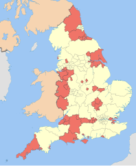
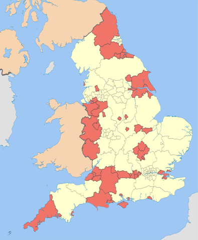
English: Map showing the unitary authorities of England highlighted, together with the all the other top-tier administrative subdivisions (shire counties, metropolitan counties, and London boroughs) from 2009 (still valid in 2012).
Equirectangular map projection on WGS 84 datum, with N/S stretched 170% Geographic limits:
|
| Datum | (UTC) |
| Bron |
This file was derived from: English administrative divisions 2010.svg:  |
| Outeur |
|
| Ander weergawes |
| This is a retouched picture, which means that it has been digitally altered from its original version. Modifications: recoloured with some thicker boundary lines. The original can be viewed here: English administrative divisions 2010.svg:
|
Lisensiëring
Ek, die outeursreghouer van hierdie werk, publiseer dit onder die volgende lisensie:
Hierdie lêer is gelisensieer onder die Creative Commons Erkenning-Insgelyks Deel 3.0 Onoorgedraagde lisensie.
Naamsvermelding: Nilfanion and Dr Greg
- U is vry:
- om te deel – die werk kopieer, versprei en deurgee
- om te hermeng – om die werk aan te pas
- Onder die volgende voorwaardes:
- naamsvermelding – U moet die nodige krediet gee, 'n skakel na die lisensie verskaf en aandui of daar veranderinge aangebring is. U mag dit op enige redelike manier doen, maar nie op enige manier wat daarop dui dat die lisensiegewer u of u gebruik onderskryf nie.
- insgelyks – As u die materiaal hermix, transformeer of voortbou, moet u u bydraes versprei onder die dieselfde of versoenbare lisensie as die oorspronklike.

|
Toestemming word verleen tot die kopiëring, verspreiding en/of wysiging van hierdie dokument onder die voorwaardes van die GNU-lisensie vir vrye dokumentasie, weergawe 1.2 of enige latere weergawe uitgegee deur die Stigting vir Vrye Sagteware, sonder Invariante Dele, geen Voorbladtekste en geen Agterbladtekste. 'n Kopie van hierdie lisensie is ingesluit in die afdeling getiteld GNU Free Documentation License. |
U kan die lisensie van u keuse kies.
Oorspronklike oplaailogboek
This image is a derivative work of the following images:
- File:English_administrative_divisions_2010.svg licensed with Cc-by-sa-3.0, GFDL
- 2010-11-23T22:02:28Z Nilfanion 1108x1345 (374390 Bytes) England only
- 2010-11-23T22:00:33Z Nilfanion 1108x1345 (410564 Bytes) {{Information |Description=Map showing the all top-tier administrative subdivisions of England (shire counties, metropolitan counties, London boroughs and Unitary Authorities) in 2010 Equirectangular map projection on WGS 84
Uploaded with derivativeFX
Lêergeskiedenis
Klik op die datum/tyd om te sien hoe die lêer destyds gelyk het.
| Datum/Tyd | Duimnael | Dimensies | Gebruiker | Opmerking | |
|---|---|---|---|---|---|
| huidig | 23:50, 8 April 2019 | | 1 039 × 1 261 (1 MG) | The Equalizer | Prior image had cropped sides |
| 23:47, 8 April 2019 |  | 744 × 1 052 (1 MG) | The Equalizer | Prior upload not displaying | |
| 23:04, 8 April 2019 |  | 1 108 × 1 345 (204 KG) | The Equalizer | Updated UAs in Dorset | |
| 12:23, 6 Mei 2012 |  | 1 108 × 1 345 (380 KG) | Dr Greg | paler boundary lines | |
| 22:17, 20 Maart 2012 |  | 1 108 × 1 345 (376 KG) | Dr Greg | == {{int:filedesc}} == {{Information |Description={{en|1=Map showing the en:unitary authorities of England highlighted, together with the all the other top-tier administrative subdivisions (shire counties, metropolitan counties, and London boroug... |
Lêergebruik
Die volgende bladsy gebruik dié lêer:
Globale lêergebruik
Die volgende ander wiki's gebruik hierdie lêer:
- Gebruik in fr.wikipedia.org
- Gebruik in hr.wikipedia.org
- Gebruik in it.wikipedia.org
- Gebruik in ja.wikipedia.org
- Gebruik in ko.wikipedia.org
- Gebruik in no.wikipedia.org
- Gebruik in oc.wikipedia.org
- Gebruik in sh.wikipedia.org