
Lêer:Liechtenstein topographic map-de Version Tschubby.png

Grootte van hierdie voorskou: 458 × 599 piksels. Ander resolusies: 183 × 240 piksels | 367 × 480 piksels | 587 × 768 piksels | 783 × 1 024 piksels | 2 189 × 2 862 piksels.
Oorspronklike lêer (2 189 × 2 862 piksels, lêergrootte: 2,2 MG, MIME-tipe: image/png)
Opsomming
| Beskrywing |
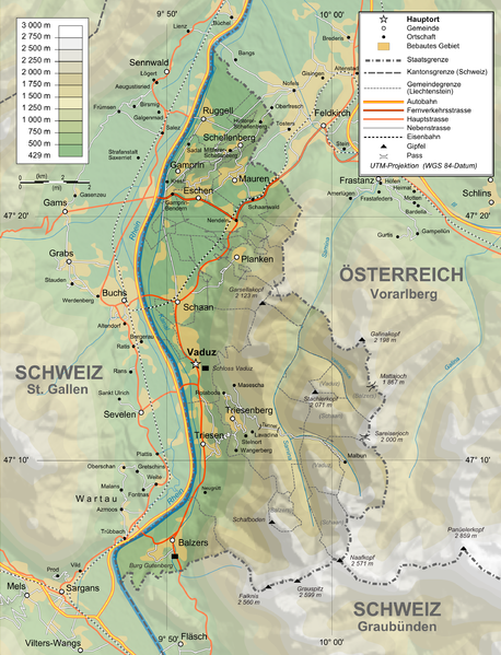
Deutsch: Topographische Karte von Liechtenstein, deutsche Version English: Topographic map in German of Liechtenstein Français : Carte topographique en allemand du Liechtenstein |
| Datum | |
| Bron |
English: Own work ; Topographic data from the NASA Shuttle Radar Topography Mission (SRTM3 v.2) (public domain) edited with 3DEM and dlgv32 Pro, and vectorized with Inkscape ; UTM projection ; WGS84 datum ; shaded relief (N-W lightning positions) edited with The Gimp ; Reference used for the additional data : * Rivers, cities, railroads, routes, bathymetry : Demis add-on for World Wind (see the approval e-mail and the Demis forum) ; * Borders and coast : World data bank II + + File:Liechtenstein-admin.png by user:Aotearoa ; Approximate scale of topographic data : 1:1,463,000 ; Note : The shaded relief is a raster image embedded in the SVG file. Français : Création personnelle ; Données topographiques de la NASA Shuttle Radar Topography Mission (SRTM3 v.2) (domaine public) éditées avec 3DEM etdlgv32 Pro, et vectorisées avec Inkscape ; projection UTM ; WGS84 datum ; relief ombré (éclairage du N-O) édité avec The Gimp ; Références utilisées pour les données complémentaires : * Rivières, villes, chemins de fers, routes, bathymétrie : Demis add-on for World Wind (cf. l'e-mail d'approbation de Demis et le Demis forum) ; * Frontières et côtes : World data bank II + File:Liechtenstein-admin.png de user:Aotearoa ; Échelle approximative des données topographiques : 1:1 463 000 ; Note : Le relief ombré est une image bitmap embarquée dans le fichier SVG. Approximate geographic limits of the map (30" close) : * SW corner : 47°02'05"N – 9°40'00"E * SE corner : 47°02'05"N – 9°70'00"E * NE corner : 47°27'55"N – 9°70'00"E * NW corner : 47°27'55"N – 9°40'00"E |
| Outeur | Bourrichon, translated by NordNordWest, new Design by Tschubby |
| Toestemming (Hergebruik van die lêer) |
GFDL / Attribution and Share-Alike required |
| Ander weergawes |
|


Lisensiëring
Ek, die outeursreghouer van hierdie werk, publiseer dit onder die volgende lisensie:

|
Toestemming word verleen tot die kopiëring, verspreiding en/of wysiging van hierdie dokument onder die voorwaardes van die GNU-lisensie vir vrye dokumentasie, weergawe 1.2 of enige latere weergawe uitgegee deur die Stigting vir Vrye Sagteware, sonder Invariante Dele, geen Voorbladtekste en geen Agterbladtekste. 'n Kopie van hierdie lisensie is ingesluit in die afdeling getiteld GNU Free Documentation License. |
This file is licensed under the Creative Commons Attribution-Share Alike 4.0 International, 3.0 Unported, 2.5 Generic, 2.0 Generic and 1.0 Generic license.
- U is vry:
- om te deel – die werk kopieer, versprei en deurgee
- om te hermeng – om die werk aan te pas
- Onder die volgende voorwaardes:
- naamsvermelding – U moet die nodige krediet gee, 'n skakel na die lisensie verskaf en aandui of daar veranderinge aangebring is. U mag dit op enige redelike manier doen, maar nie op enige manier wat daarop dui dat die lisensiegewer u of u gebruik onderskryf nie.
- insgelyks – As u die materiaal hermix, transformeer of voortbou, moet u u bydraes versprei onder die dieselfde of versoenbare lisensie as die oorspronklike.
U kan die lisensie van u keuse kies.
Lêergeskiedenis
Klik op die datum/tyd om te sien hoe die lêer destyds gelyk het.
| Datum/Tyd | Duimnael | Dimensies | Gebruiker | Opmerking | |
|---|---|---|---|---|---|
| huidig | 14:05, 3 Februarie 2016 | | 2 189 × 2 862 (2,2 MG) | RokerHRO | optipng -o7 -zm1-9 -i0 → 48.70% decrease |
| 11:37, 12 Februarie 2012 |  | 2 189 × 2 862 (4,3 MG) | Tschubby | {{Information |Description= |Source= |Date= |Author= |Permission= |other_versions= }} | |
| 11:31, 12 Februarie 2012 |  | 2 189 × 2 862 (8,6 MG) | Tschubby | {{Information |Description= |Source= |Date= |Author= |Permission= |other_versions= }} | |
| 16:17, 26 Januarie 2012 |  | 1 305 × 1 683 (2,3 MG) | Tschubby | {{Information |Description= |Source= |Date= |Author= |Permission= |other_versions= }} | |
| 16:13, 26 Januarie 2012 |  | 794 × 1 024 (1,26 MG) | Tschubby | {{Information |Description= |Source= |Date= |Author= |Permission= |other_versions= }} | |
| 09:05, 21 Julie 2009 |  | 1 305 × 1 683 (1,46 MG) | Tschubby | {{Information |Description= |Source= |Date= |Author= |Permission= |other_versions= }} | |
| 08:50, 21 Julie 2009 |  | 1 338 × 1 683 (1,48 MG) | Tschubby | == Summary == {{Information |Description={{de|Topographische Karte von Liechtenstein, deutsche Version}}{{en|Topographic map in German of Liechtenstein}}{{fr|Carte topographique en allemand du [[:fr:Liechtenstei |
Lêergebruik
Die volgende bladsy gebruik dié lêer:
Globale lêergebruik
Die volgende ander wiki's gebruik hierdie lêer:
- Gebruik in als.wikipedia.org
- Gebruik in de.wikipedia.org
- Gebruik in es.wikipedia.org
- Gebruik in fo.wikipedia.org
- Gebruik in frr.wikipedia.org
- Gebruik in pdc.wikipedia.org
- Gebruik in pfl.wikipedia.org
- Gebruik in rm.wikipedia.org