
Lêer:Main-Karte-160710.jpg

Grootte van hierdie voorskou: 800 × 560 piksels. Ander resolusies: 320 × 224 piksels | 640 × 448 piksels | 1 024 × 716 piksels | 1 280 × 896 piksels | 2 560 × 1 791 piksels | 3 000 × 2 099 piksels.
Oorspronklike lêer (3 000 × 2 099 piksels, lêergrootte: 3,28 MG, MIME-tipe: image/jpeg)
Opsomming
| Beskrywing |
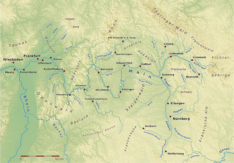
Karte des Verlaufs des Flusses Main Erstellt unter Zuhilfenahme von SRTM-Daten, Quantum GIS, Generic Mapping Tools, GPS-Trackmaker |
| Datum | |
| Bron | Eie werk |
| Outeur | BerndH |
| Toestemming (Hergebruik van die lêer) |
CC/GFDL |
Lisensiëring
Ek, die outeursreghouer van hierdie werk, publiseer dit onder die volgende lisensie:
Hierdie lêer is gelisensieer onder die Creative Commons Erkenning-Insgelyks Deel 3.0 Onoorgedraagde lisensie.
- U is vry:
- om te deel – die werk kopieer, versprei en deurgee
- om te hermeng – om die werk aan te pas
- Onder die volgende voorwaardes:
- naamsvermelding – U moet die nodige krediet gee, 'n skakel na die lisensie verskaf en aandui of daar veranderinge aangebring is. U mag dit op enige redelike manier doen, maar nie op enige manier wat daarop dui dat die lisensiegewer u of u gebruik onderskryf nie.
- insgelyks – As u die materiaal hermix, transformeer of voortbou, moet u u bydraes versprei onder die dieselfde of versoenbare lisensie as die oorspronklike.

|
Toestemming word verleen tot die kopiëring, verspreiding en/of wysiging van hierdie dokument onder die voorwaardes van die GNU-lisensie vir vrye dokumentasie, weergawe 1.2 of enige latere weergawe uitgegee deur die Stigting vir Vrye Sagteware, sonder Invariante Dele, geen Voorbladtekste en geen Agterbladtekste. 'n Kopie van hierdie lisensie is ingesluit in die afdeling getiteld GNU Free Documentation License. |
U kan die lisensie van u keuse kies.
Lêergeskiedenis
Klik op die datum/tyd om te sien hoe die lêer destyds gelyk het.
| Datum/Tyd | Duimnael | Dimensies | Gebruiker | Opmerking | |
|---|---|---|---|---|---|
| huidig | 20:01, 5 Januarie 2021 | | 3 000 × 2 099 (3,28 MG) | NordNordWest | Haßfurt -> Haßfurt |
| 17:14, 16 Julie 2010 |  | 3 000 × 2 099 (4,99 MG) | BerndH | {{Information |Description= Karte des Verlaufs des Flusses Main<br/>Erstellt unter Zuhilfenahme von SRTM-Daten, Quantum GIS, Generic Mapping Tools, GPS-Trackmaker |Source={{own}} |Date= 16. Juli 2010 |Author=BerndH |Permission= CC/GFDL |ot |
Lêergebruik
Die volgende bladsy gebruik dié lêer:
Globale lêergebruik
Die volgende ander wiki's gebruik hierdie lêer:
- Gebruik in als.wikipedia.org
- Gebruik in de.wikipedia.org
- Gebruik in de.wikibooks.org
- Gebruik in en.wikipedia.org
- Gebruik in es.wikipedia.org
- Gebruik in frr.wikipedia.org
- Gebruik in fr.wikipedia.org
- Gebruik in fy.wikipedia.org
- Gebruik in he.wikipedia.org
- Gebruik in incubator.wikimedia.org
- Gebruik in li.wikipedia.org
- Gebruik in lmo.wikipedia.org
- Gebruik in lv.wikipedia.org
- Gebruik in ml.wikipedia.org
- Gebruik in mt.wikipedia.org
- Gebruik in nl.wikipedia.org
- Gebruik in no.wikipedia.org
- Gebruik in pl.wikipedia.org
- Gebruik in sl.wikipedia.org
- Gebruik in sr.wikipedia.org
- Gebruik in stq.wikipedia.org
- Gebruik in th.wikipedia.org
- Gebruik in tr.wikipedia.org
- Gebruik in www.wikidata.org
- Gebruik in xmf.wikipedia.org
- Gebruik in zh.wikipedia.org