
Lêer:Mare Tranquillitatis map.jpg
Geen hoër resolusie is beskikbaar nie.
Mare_Tranquillitatis_map.jpg (343 × 344 piksels, lêergrootte: 69 KG, MIME-tipe: image/jpeg)
Opsomming
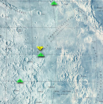
Map of Mare Tranquillitatis, cropped from http://www.jpl.nasa.gov/history/60s/Surveyor7_1968.htm.
The colored arrows indicate the landing sites of Apollo 11, the first manned moon mission, Apollo 17, Apollo 16, and Surveyor 5. To the southeast is Mare Fecunditatis, to the northeast is Mare Crisium, and to the south is Mare Nectaris.
Secondary source: http://en.wikipedia.org/wiki/Image:Mare_Tranquillitatis_map.jpg
Lisensiëring
| This file is in the public domain in the United States because it was solely created by NASA. NASA copyright policy states that "NASA material is not protected by copyright unless noted". (See Template:PD-USGov, NASA copyright policy page or JPL Image Use Policy.) | ||
 |
Warnings:
|
Lêergeskiedenis
Klik op die datum/tyd om te sien hoe die lêer destyds gelyk het.
| Datum/Tyd | Duimnael | Dimensies | Gebruiker | Opmerking | |
|---|---|---|---|---|---|
| huidig | 23:00, 25 Augustus 2005 | | 343 × 344 (69 KG) | Mattes | new |
Lêergebruik
Die volgende bladsy gebruik dié lêer:
Globale lêergebruik
Die volgende ander wiki's gebruik hierdie lêer:
- Gebruik in bg.wikipedia.org
- Gebruik in cs.wikipedia.org
- Gebruik in da.wikipedia.org
- Gebruik in de.wikipedia.org
- Gebruik in en.wikipedia.org
- Gebruik in es.wikipedia.org
- Gebruik in fa.wikipedia.org
- Gebruik in fi.wikipedia.org
- Gebruik in fr.wikipedia.org
- Gebruik in he.wikipedia.org
- Gebruik in id.wikipedia.org
- Gebruik in it.wikipedia.org
- Gebruik in ka.wikipedia.org
- Gebruik in ko.wikipedia.org
- Gebruik in lb.wikipedia.org
- Gebruik in nl.wikipedia.org
- Gebruik in pl.wikipedia.org
- Gebruik in pt.wikipedia.org
- Gebruik in ro.wikipedia.org
- Gebruik in ru.wikipedia.org
- Gebruik in simple.wikipedia.org
- Gebruik in sv.wikipedia.org
- Gebruik in zh.wikipedia.org