
Lêer:Naddniestrze-administracja.png

Grootte van hierdie voorskou: 408 × 599 piksels. Ander resolusies: 163 × 240 piksels | 327 × 480 piksels | 922 × 1 354 piksels.
Oorspronklike lêer (922 × 1 354 piksels, lêergrootte: 155 KG, MIME-tipe: image/png)
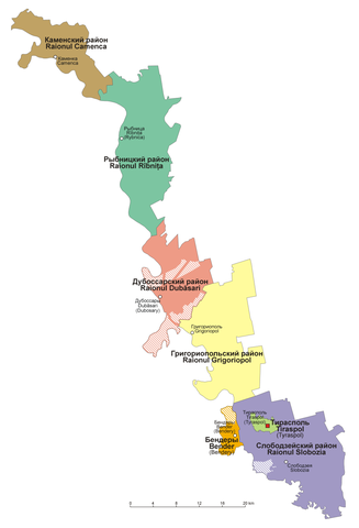
Opsomming
| Beskrywing |
English: Administrative divisions of Pridnestrovie
Polski: Mapa administracyjna Naddniestrza |
| Datum | |
| Bron | Eie werk |
| Outeur | Aotearoa |
Lisensiëring
Ek, die outeursreghouer van hierdie werk, publiseer dit onder die volgende lisensie:

|
Toestemming word verleen tot die kopiëring, verspreiding en/of wysiging van hierdie dokument onder die voorwaardes van die GNU-lisensie vir vrye dokumentasie, weergawe 1.2 of enige latere weergawe uitgegee deur die Stigting vir Vrye Sagteware, sonder Invariante Dele, geen Voorbladtekste en geen Agterbladtekste. 'n Kopie van hierdie lisensie is ingesluit in die afdeling getiteld GNU Free Documentation License. |
| Hierdie lêer is gelisensieer onder die Creative Commons Erkenning-Insgelyks Deel 3.0 Onoorgedraagde lisensie. | ||
| ||
| This licensing tag was added to this file as part of the GFDL licensing update. |
U kan die lisensie van u keuse kies.
Lêergeskiedenis
Klik op die datum/tyd om te sien hoe die lêer destyds gelyk het.
| Datum/Tyd | Duimnael | Dimensies | Gebruiker | Opmerking | |
|---|---|---|---|---|---|
| huidig | 08:27, 28 Maart 2019 | | 922 × 1 354 (155 KG) | Aotearoa | Reverted to version as of 14:08, 3 August 2015 (UTC) - incorrect text |
| 19:33, 13 Augustus 2017 |  | 922 × 1 354 (59 KG) | MAXHO | Correction according with all sources and travellers, with NordNordWest's map [https://commons.wikimedia.org/wiki/File:Moldova_location_map.svg], with Aotearoa's original maps [https://commons.wikimedia.org/wiki/File:Naddniestrze.png], [https://common... | |
| 17:14, 23 Februarie 2017 |  | 922 × 1 354 (43 KG) | Nicolay Sidorov | de-facto borders | |
| 14:08, 3 Augustus 2015 |  | 922 × 1 354 (155 KG) | Aotearoa | Reverted to version as of 20:17, 26 August 2008 - this is map in Polish, English text might be added in duplicated file | |
| 17:02, 2 Augustus 2015 |  | 922 × 1 354 (171 KG) | Spiridon Ion Cepleanu | Legend of the striped areas | |
| 20:17, 26 Augustus 2008 |  | 922 × 1 354 (155 KG) | Aotearoa | {{Information |Description={{en|1=Administrative divisions of Transnistria}} {{pl|1=Mapa administracyjna Naddniestrza}} |Source=Praca własna osoby przesyłającej (own work by uploader) |Author=Aotearoa |Date=26.08.2008 |Permission= |ot |
Lêergebruik
Daar is geen bladsye wat dié lêer gebruik nie.
Globale lêergebruik
Die volgende ander wiki's gebruik hierdie lêer:
- Gebruik in ca.wikipedia.org
- Gebruik in csb.wikipedia.org
- Gebruik in de.wikipedia.org
- Gebruik in gag.wikipedia.org
- Gebruik in pl.wikipedia.org
- Gebruik in pl.wikivoyage.org
- Gebruik in ru.wikipedia.org
- Gebruik in tr.wikipedia.org
- Gebruik in uk.wikipedia.org