
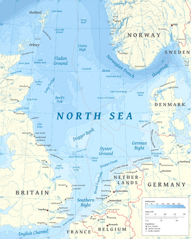
Lêer:North Sea map-en.png

Grootte van hierdie voorskou: 479 × 600 piksels. Ander resolusies: 192 × 240 piksels | 383 × 480 piksels | 613 × 768 piksels | 817 × 1 024 piksels | 2 475 × 3 100 piksels.
Oorspronklike lêer (2 475 × 3 100 piksels, lêergrootte: 3,8 MG, MIME-tipe: image/png)
P
Opsomming
| Beskrywing | |
| Datum | |
| Bron |
Eie werk using en:GRASS GIS, en:Inkscape and en:GIMP. Data sources:
Map Projection: Universal Transverse Mercator Typeface: Gentium Book Basic from SIL International |
| Outeur | Halava |
| Ander weergawes |
  |
Lisensiëring
Ek, die outeursreghouer van hierdie werk, publiseer dit onder die volgende lisensie:
Hierdie lêer is gelisensieer onder die Creative Commons Erkenning-Insgelyks Deel 3.0 Onoorgedraagde lisensie.
- U is vry:
- om te deel – die werk kopieer, versprei en deurgee
- om te hermeng – om die werk aan te pas
- Onder die volgende voorwaardes:
- naamsvermelding – U moet die nodige krediet gee, 'n skakel na die lisensie verskaf en aandui of daar veranderinge aangebring is. U mag dit op enige redelike manier doen, maar nie op enige manier wat daarop dui dat die lisensiegewer u of u gebruik onderskryf nie.
- insgelyks – As u die materiaal hermix, transformeer of voortbou, moet u u bydraes versprei onder die dieselfde of versoenbare lisensie as die oorspronklike.

|
Toestemming word verleen tot die kopiëring, verspreiding en/of wysiging van hierdie dokument onder die voorwaardes van die GNU-lisensie vir vrye dokumentasie, weergawe 1.2 of enige latere weergawe uitgegee deur die Stigting vir Vrye Sagteware, sonder Invariante Dele, geen Voorbladtekste en geen Agterbladtekste. 'n Kopie van hierdie lisensie is ingesluit in die afdeling getiteld GNU Free Documentation License. |
U kan die lisensie van u keuse kies.
| Annotations | This image is annotated: View the annotations at Commons |
Lêergeskiedenis
Klik op die datum/tyd om te sien hoe die lêer destyds gelyk het.
| Datum/Tyd | Duimnael | Dimensies | Gebruiker | Opmerking | |
|---|---|---|---|---|---|
| huidig | 17:23, 5 Maart 2015 | | 2 475 × 3 100 (3,8 MG) | Tandru7 | {{Information |Description=Map of the North Sea |Source=Wiki Commons |Date=3/5/15 |Author= |Permission= |other_versions= }} |
| 14:48, 15 Oktober 2010 |  | 2 475 × 3 100 (3,8 MG) | Halava | New place names | |
| 17:34, 12 Oktober 2010 |  | 2 475 × 3 100 (3,79 MG) | Halava | Some corrections; several new place names | |
| 11:02, 12 Oktober 2010 |  | 2 475 × 3 100 (3,78 MG) | Halava | Minor corrections; improved legibility; Horns Rev | |
| 08:09, 10 Oktober 2010 |  | 2 475 × 3 100 (3,72 MG) | Halava | Exclusive economic zones; Heligoland | |
| 09:26, 9 Oktober 2010 |  | 2 475 × 3 100 (3,64 MG) | Halava | Lindisfarne; Norfolk Banks instead of Wells Bank | |
| 20:27, 8 Oktober 2010 |  | 2 475 × 3 100 (3,63 MG) | Halava | Outlined Dogger Bank, fixed a typo | |
| 17:04, 8 Oktober 2010 |  | 2 475 × 3 100 (3,61 MG) | Halava | Several improvements | |
| 10:52, 6 Oktober 2010 |  | 2 475 × 3 100 (3,37 MG) | Halava | Fixed two typos, switched color model to RGB | |
| 10:09, 6 Oktober 2010 |  | 2 475 × 3 100 (2,57 MG) | Halava | {{Information |Description={{en|1=Map of the North Sea.}} |Source={{own}} using GRASS GIS, Inkscape and GIMP. Data sources: * Elevation and bathymetry data from NGDC ETOPO1 * Coastlines, rivers and borders from NGDC World Data Bank II * Cities from OpenS |
Lêergebruik
Die volgende bladsy gebruik dié lêer:
Globale lêergebruik
Die volgende ander wiki's gebruik hierdie lêer:
- Gebruik in ar.wikipedia.org
- Gebruik in arz.wikipedia.org
- Gebruik in ast.wikipedia.org
- Gebruik in ba.wikipedia.org
- Gebruik in be-tarask.wikipedia.org
- Gebruik in bg.wikipedia.org
- Gebruik in br.wikipedia.org
- Gebruik in ca.wikipedia.org
- Gebruik in cs.wikipedia.org
- Gebruik in cy.wikipedia.org
- Gebruik in de.wikipedia.org
- Gebruik in de.wikivoyage.org
- Gebruik in el.wikipedia.org
- Gebruik in en.wikipedia.org
- North Sea
- Skagerrak
- SMS Lützow
- HMS King Edward VII
- HMS Marlborough (1912)
- HMS Emperor of India
- HMS Africa (1905)
- Horns Rev
- HMS Britannia (1904)
- Silverpit crater
- Broad Fourteens
- Dogger Bank
- Long Forties
- HMS Hibernia (1905)
- Fisher Bank
- Norwegian trench
- Silver Pit
- Wikipedia:Userboxes/Location
- Operation Wikinger
- HMS Commonwealth
- Northern Patrol
- Raid on Scarborough, Hartlepool and Whitby
- HMS Hindustan (1903)
- User:Buaidh
- Southern Bight
- History of the North Sea
- First Ostend Raid
- Bombardment of Yarmouth and Lowestoft
- HMS Dominion
Wys meer globale gebruik van die lêer.