
Lêer:South China Sea vector.svg

Size of this PNG preview of this SVG file: 637 × 600 piksels. Ander resolusies: 255 × 240 piksels | 510 × 480 piksels | 816 × 768 piksels | 1 088 × 1 024 piksels | 2 176 × 2 048 piksels | 1 004 × 945 piksels.
Oorspronklike lêer (SVG-lêer, normaalweg 1 004 × 945 piksels, lêergrootte: 657 KG)
Opsomming
| Beskrywing |
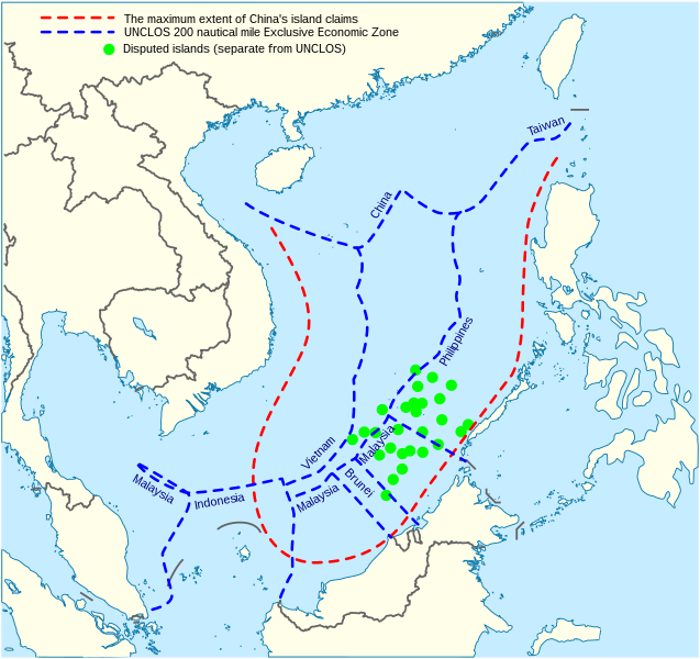
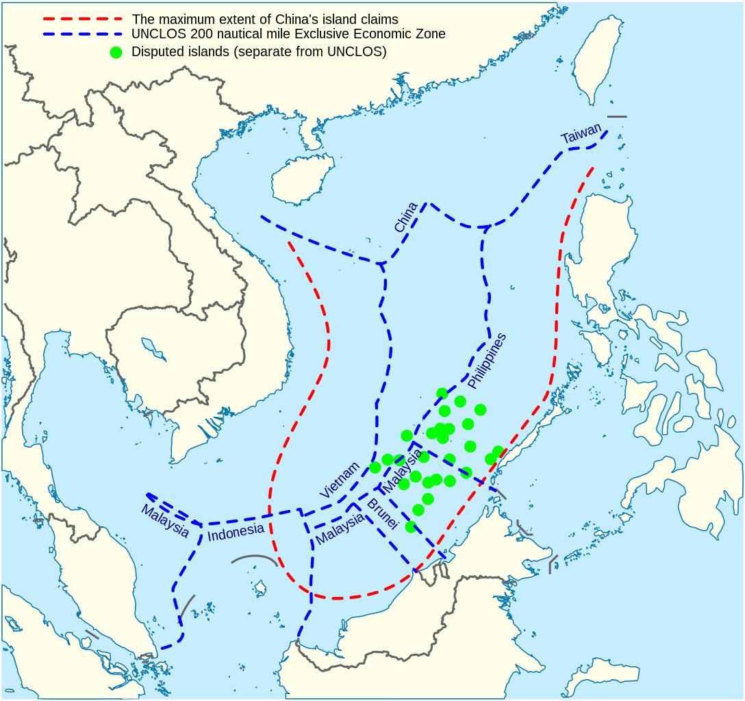
English: China's maritime claim (red) and UNCLOS exclusive economic zones (blue) in the South China Sea |
| Datum | |
| Bron |
Eie werk |
| Outeur | Goran tek-en |
| SVG genesis | This vector image was created with Inkscape. |


Lisensiëring
This file is licensed under the Creative Commons Attribution-Share Alike 4.0 International license.
Naamsvermelding: Goran tek-en
- U is vry:
- om te deel – die werk kopieer, versprei en deurgee
- om te hermeng – om die werk aan te pas
- Onder die volgende voorwaardes:
- naamsvermelding – U moet die nodige krediet gee, 'n skakel na die lisensie verskaf en aandui of daar veranderinge aangebring is. U mag dit op enige redelike manier doen, maar nie op enige manier wat daarop dui dat die lisensiegewer u of u gebruik onderskryf nie.
- insgelyks – As u die materiaal hermix, transformeer of voortbou, moet u u bydraes versprei onder die dieselfde of versoenbare lisensie as die oorspronklike.
Lêergeskiedenis
Klik op die datum/tyd om te sien hoe die lêer destyds gelyk het.
| Datum/Tyd | Duimnael | Dimensies | Gebruiker | Opmerking | |
|---|---|---|---|---|---|
| huidig | 14:31, 15 Februarie 2022 | | 1 004 × 945 (657 KG) | ماني | File uploaded using svgtranslate tool (https://svgtranslate.toolforge.org/). Added translation for fa. |
| 15:44, 16 November 2021 |  | 1 004 × 945 (651 KG) | Goran tek-en | ppi to 96, optimized, cleaned up | |
| 19:40, 9 November 2014 |  | 1 004 × 945 (729 KG) | Cmglee | Label UNCLOS regions. | |
| 23:15, 19 Mei 2014 |  | 1 004 × 945 (723 KG) | Benlisquare | Fix misinformation, see en:Talk:Nine-dotted line. The red line represents the extent of China's island claims, and not sea territory claims. China's maritime territorial claims are based on distance from claimed islands, and are not demarcated by... | |
| 14:40, 23 Januarie 2014 |  | 1 004 × 945 (722 KG) | Goran tek-en | User created page with UploadWizard |
Lêergebruik
Die volgende bladsy gebruik dié lêer:
Globale lêergebruik
Die volgende ander wiki's gebruik hierdie lêer:
- Gebruik in cs.wikinews.org
- Gebruik in en.wikipedia.org
- Gebruik in fa.wikipedia.org
- Gebruik in fi.wikipedia.org
- Gebruik in fr.wikinews.org
- Gebruik in fr.wiktionary.org
- Gebruik in ja.wikipedia.org
- Gebruik in kk.wikipedia.org
- Gebruik in ko.wikipedia.org
- Gebruik in pl.wikipedia.org
- Gebruik in ru.wikipedia.org
- Gebruik in th.wikipedia.org
- Gebruik in vi.wikipedia.org