
Lêer:Sydney Harbour Bridge night.jpg

Grootte van hierdie voorskou: 800 × 200 piksels. Ander resolusies: 320 × 80 piksels | 640 × 160 piksels | 1 024 × 256 piksels | 1 280 × 320 piksels | 2 560 × 639 piksels | 13 742 × 3 431 piksels.
Oorspronklike lêer (13 742 × 3 431 piksels, lêergrootte: 10,9 MG, MIME-tipe: image/jpeg)
Opsomming
| Beskrywing |
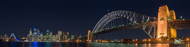
English: A panoramic view of the Sydney Harbour Bridge at night, as seen from the North Shore suburb of Kirribilli.
Français : Le Harbour Bridge vu depuis Kirribilli, une commune de la banlieue de Sydney sur la rive nord.
中文:从克里比利北岸拍摄的悉尼港大桥。 |
| Datum | Taken on 15 Junie 2005 |
| Bron | taken by Diliff |
| Outeur | Diliff |
| Toestemming (Hergebruik van die lêer) |
Summary:In using this image or any subsequent derivatives of it, you are required to release the image under the same license. As such, any reproduction of this image, in any medium, must appear with a copy of, or full URL of the license.Attribution of this image to the author (DAVID ILIFF) is also required, preferably in a prominent location near the image.No other conditions may be added to, or removed from this license without the permission of the author and copyright holder.Suggested attribution: "Photo by DAVID ILIFF. License: CC BY-SA 3.0"Please review the full license requirements carefully before using this image. If you would like to clarify the terms of the license or negotiate less restrictive commercial licensing outside of the bounds of GFDL/CC-BY-SA, please contact me by email, or if you don't have a Wikipedia account you can either leave a message on my talk page with your contact details and your request, or you can contact me on Facebook. Please also send a 'friend request' to ensure that I am aware of your message. |
| Ander weergawes |
copied from en.wikipedia |
| Kameraligging | | Hierdie en ander beelde in: OpenStreetMap |
|---|
Lisensiëring
Ek, die outeursreghouer van hierdie werk, publiseer dit onder die volgende lisensie:
Hierdie lêer is gelisensieer onder die Creative Commons Erkenning-Insgelyks Deel 3.0 Onoorgedraagde lisensie.
- U is vry:
- om te deel – die werk kopieer, versprei en deurgee
- om te hermeng – om die werk aan te pas
- Onder die volgende voorwaardes:
- naamsvermelding – U moet die nodige krediet gee, 'n skakel na die lisensie verskaf en aandui of daar veranderinge aangebring is. U mag dit op enige redelike manier doen, maar nie op enige manier wat daarop dui dat die lisensiegewer u of u gebruik onderskryf nie.
- insgelyks – As u die materiaal hermix, transformeer of voortbou, moet u u bydraes versprei onder die dieselfde of versoenbare lisensie as die oorspronklike.

|
Toestemming word verleen tot die kopiëring, verspreiding en/of wysiging van hierdie dokument onder die voorwaardes van die GNU-lisensie vir vrye dokumentasie, weergawe 1.2 of enige latere weergawe uitgegee deur die Stigting vir Vrye Sagteware, sonder Invariante Dele, geen Voorbladtekste en geen Agterbladtekste. 'n Kopie van hierdie lisensie is ingesluit in die afdeling getiteld GNU Free Documentation License. |
U kan die lisensie van u keuse kies.
Assessment
|

Hierdie beeld is gekies as beeld van die dag op 5 Oktober 2006. Die beeld het die volgende beskrywing: English: Sydney Harbour Bridge Ander tale:
Cymraeg: Pont Harbwr Sydney Deutsch: Hafenbrücke in Sydney English: Sydney Harbour Bridge Español: Puente del puerto de Sídney, Australia. Magyar: A Sydney Harbour-híd Norsk nynorsk: Sydney Harbour Bridge Polski: Most portowy w Sydney (Harbour Bridge) Português: Ponte do porto de Sydney Slovenščina: Sydneyjski pristaniški most Svenska: Sydney Harbour Bridge Русский: Мост в гавани (Harbour Bridge), Сидней 中文: 悉尼港大桥 العربية : جسر ميناء مدينة سيدني |
| Annotations | This image is annotated: View the annotations at Commons |
Lêergeskiedenis
Klik op die datum/tyd om te sien hoe die lêer destyds gelyk het.
| Datum/Tyd | Duimnael | Dimensies | Gebruiker | Opmerking | |
|---|---|---|---|---|---|
| huidig | 14:03, 19 Junie 2013 | 13 742 × 3 431 (10,9 MG) | Diliff | reprocessed... different colour balance, slightly wider view. | |
| 03:05, 29 November 2005 | 6 412 × 1 445 (2,43 MG) | Thuresson | Sydney Harbour Bridge as seen from the North Shore suburb of Kirribilli. Taken on the 15th of June, 2005. Image history at en: (del) (cur) 16:46, 10 September 2005 . . Diliff . . 6412x1445 (2548430 bytes) (del) (rev) 08:38, 28 Augus |
Lêergebruik
Die volgende 4 bladsye gebruik dié lêer:
Globale lêergebruik
Die volgende ander wiki's gebruik hierdie lêer:
- Gebruik in ar.wikipedia.org
- Gebruik in ba.wikipedia.org
- Gebruik in be-tarask.wikipedia.org
- Gebruik in be.wikipedia.org
- Gebruik in bg.wikipedia.org
- Gebruik in bn.wikipedia.org
- Gebruik in ca.wikipedia.org
- Gebruik in cs.wikipedia.org
- Gebruik in da.wikipedia.org
- Gebruik in de.wikipedia.org
- Wikipedia:Kandidaten für exzellente Bilder/Archiv2006/17
- Datei:Sydney Harbour Bridge night.jpg
- Portal:Planung/Bilder Galerie
- Benutzer:Symbiosus/Gallerie der Lieblingsbilder
- Wikipedia:Exzellente Bilder/Kunst und Kultur
- Benutzer:Mikullovci11/Work/Sonstige Fotos
- Benutzer:Der Wolf im Wald/Lieblingsbilder
- Benutzer:HerrSonderbar/Rubrik Orte
- Gebruik in diq.wikipedia.org
- Gebruik in en.wikipedia.org
- Sydney Harbour Bridge
- Panoramic photography
- Urban area
- User talk:Chowells
- Wikipedia:Picture of the day/December 2005
- Wikipedia:Featured pictures thumbs/03
- Wikipedia:Today's second feature/December 2005
- Wikipedia:Featured picture candidates/Sydney Harbour Bridge
- Wikipedia:Featured picture candidates/October-2005
- User:Diliff
- Wikipedia:Wikipedia Signpost/2005-10-24/Features and admins
- Wikipedia:Australian Wikipedians' notice board/Welcome
- Wikipedia:WikiProject Bridges and Tunnels
- User:Cyde/Featured pictures
- Wikipedia:Picture of the day/December 25, 2005
- Wikipedia:POTD/December 25, 2005
- Wikipedia:Today's second feature/December 25, 2005
- Wikipedia:Featured picture candidates/February-2006
- Wikipedia:Featured picture candidates/MarinaBay
- Wikipedia:Featured picture candidates/Eastrock02
- Wikipedia:Featured picture candidates/April-2006
- Wikipedia:Featured picture candidates/Golden Bauhinia
- User talk:Diliff/Archive1
- User:Tewy
- Wikipedia:Featured pictures/Places/Panorama
- User:UniQue tree
Wys meer globale gebruik van die lêer.