
Lêer:Walvis Bay map.jpeg
Geen hoër resolusie is beskikbaar nie.
Walvis_Bay_map.jpeg (372 × 420 piksels, lêergrootte: 34 KG, MIME-tipe: image/jpeg)
Opsomming
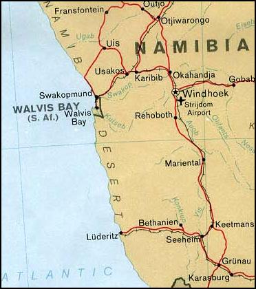
| Beskrywing | Map of Walvis Bay (Namibia) | |||
| Datum | ||||
| Bron | From the University of Texas PCL Map Collection [1] | |||
| Outeur | U.S. Central Intelligence Agency | |||
| Toestemming (Hergebruik van die lêer) |
|

Lêergeskiedenis
Klik op die datum/tyd om te sien hoe die lêer destyds gelyk het.
| Datum/Tyd | Duimnael | Dimensies | Gebruiker | Opmerking | |
|---|---|---|---|---|---|
| huidig | 04:29, 17 April 2006 | | 372 × 420 (34 KG) | Foundert~commonswiki | {{Information| |Description=Map of Walvis Bay (Namibia) from |Source=http://www.lib.utexas.edu/maps/africa/nambia_walvis_pol78.jpg from the University of Texas |Date= 09:59, 27 September 2003 |Author=User:Pascal |Permission=This file has been released in |
Lêergebruik
Die volgende bladsy gebruik dié lêer:
Globale lêergebruik
Die volgende ander wiki's gebruik hierdie lêer:
- Gebruik in bg.wikipedia.org
- Gebruik in ca.wikipedia.org
- Gebruik in ckb.wikipedia.org
- Gebruik in cs.wikipedia.org
- Gebruik in en.wikipedia.org
- Gebruik in es.wikipedia.org
- Gebruik in fa.wikipedia.org
- Gebruik in fi.wikipedia.org
- Gebruik in hr.wikipedia.org
- Gebruik in id.wikipedia.org
- Gebruik in io.wikipedia.org
- Gebruik in it.wikipedia.org
- Gebruik in ja.wikipedia.org
- Gebruik in ko.wikipedia.org
- Gebruik in mt.wikipedia.org
- Gebruik in mzn.wikipedia.org
- Gebruik in pl.wikipedia.org
- Gebruik in sco.wikipedia.org
- Gebruik in sl.wikipedia.org
- Gebruik in tg.wikipedia.org
- Gebruik in th.wikipedia.org
- Gebruik in www.wikidata.org