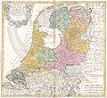
Lêer:1748 Homann Heirs Map of Holland (Netherlands) - Geographicus - BelgiumFoederatum-homannheirs-1748.jpg

Page contents not supported in other languages.
in Wikipedia, die vrye ensiklopedie

Oorspronklike lêer(4 000 × 3 659 piksels, lêergrootte: 3,8 MG, MIME-tipe: image/jpeg)

Hierdie lêer kom vanaf Wikimedia Commons en kan ook in ander projekte gebruik word. Die beskrywing op die lêer se inligtingsblad word hieronder weergegee.

Septem Provinciae seu Belgium Foederatum: quod generaliter Hollandia audit, speciali mappa delineatum, adhibitis in auxilium observationibus astronomicis nec non mensurationibus Snelii, Muschenbrokii…
Kunstenaar/Skepper
Titel
Septem Provinciae seu Belgium Foederatum: quod generaliter Hollandia audit, speciali mappa delineatum, adhibitis in auxilium observationibus astronomicis nec non mensurationibus Snelii, Muschenbrokii…
Beskrywing
English: A beautifully detailed 1748 Homann Heirs map seven states of the Belgian Federation – what is today Holland or the Netherlands. Title cartouche in the upper left quadrant features the armorial coasts of the seven states: Geldern, Holland, Zeeland, Utrecht, Friesland, Ober Issel, and Groningen. This map was drawn by Johann Tobias Mayer for inclusion the 1752 Homann Heirs Maior Atlas Scholasticus ex Triginta Sex Generalibus et Specialibus…. Most early Homann atlases were “made to order” or compiled of individual maps at the request of the buyer. However, this rare atlas, composed of 37 maps and charts, was issued as a “suggested collection” of essential Homann Heirs maps.
Datum 1748
date QS:P571,+1748-00-00T00:00:00Z/9
Dimensies Hoogte: 19 in (48,2 cm); breedte: 20,5 in (52 cm)
dimensions QS:P2048,19U218593
dimensions QS:P2049,20.5U218593
Inventarisnommer
Bron/Fotograaf
Toestemming
(Hergebruik van die lêer)
This is a faithful photographic reproduction of a two-dimensional, public domain work of art. The work of art itself is in the public domain for the following reason:
Public domain

This work is in the public domain in its country of origin and other countries and areas where the copyright term is the author's life plus 100 years or fewer.


You must also include a United States public domain tag to indicate why this work is in the public domain in the United States.
The official position taken by the Wikimedia Foundation is that "faithful reproductions of two-dimensional public domain works of art are public domain".
This photographic reproduction is therefore also considered to be in the public domain in the United States. In other jurisdictions, re-use of this content may be restricted; see Reuse of PD-Art photographs for details.

Captions

Add a one-line explanation of what this file represents

Items portrayed in this file

uitbeelding

MIME type Engels

image/jpeg

checksum Engels

88dc5bb3c5d66eeb1514843c64c96f0500367dc5

data size Engels

3 987 692 greep

height Engels

3 659 pieksel

width Engels

4 000 pieksel

Lêergeskiedenis

Klik op die datum/tyd om te sien hoe die lêer destyds gelyk het.

Datum/TydDuimnaelDimensiesGebruikerOpmerking
huidig21:22, 24 Maart 2011Duimnaelskets vir weergawe vanaf 21:22, 24 Maart 20114 000 × 3 659 (3,8 MG)BotMultichillT{{subst:User:Multichill/Geographicus |link=http://www.geographicus.com/P/AntiqueMap/BelgiumFoederatum-homannheirs-1748 |product_name=1748 Homann Heirs Map of Holland (Netherlands) |map_title=Septem Provinciae seu Belgium Foederatum: quod generaliter Holla

Die volgende bladsy gebruik dié lêer:

Globale lêergebruik

Die volgende ander wiki's gebruik hierdie lêer: