
Lêer:Map of South Africa with provinces shaded and districts numbered (2011).svg

Size of this PNG preview of this SVG file: 684 × 599 piksels. Ander resolusies: 274 × 240 piksels | 548 × 480 piksels | 876 × 768 piksels | 1 168 × 1 024 piksels | 2 337 × 2 048 piksels | 809 × 709 piksels.
Oorspronklike lêer (SVG-lêer, normaalweg 809 × 709 piksels, lêergrootte: 845 KG)
.svg)
W3C-validity not checked.
Opsomming
| Beskrywing |
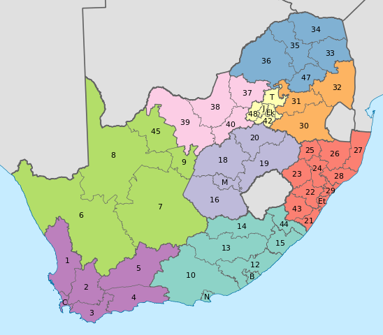
English: Map of South Africa with provincial and district boundaries. The provinces are shaded as follows:
Eastern Cape
Free State
Gauteng
KwaZulu-Natal
Limpopo
Mpumalanga
North West
Northern Cape
Western Cape
The district municipalities are labelled with their code, excluding the letters "DC"; for example, Xhariep District Municipality, which has code DC16, is labelled with a 16. The metropolitan municipalities are labelled with letters. B: Buffalo City; C: City of Cape Town; Ek: Ekurhuleni; Et: eThekwini; J: City of Johannesburg; M: Mangaung; N: Nelson Mandela Bay; T: City of Tshwane. |
| Datum | |
| Bron | Eie werk |
| Outeur | Htonl |
| Ander weergawes | File:Map of South Africa with district borders (2011).svg |
.svg)
Lisensiëring
Ek, die outeursreghouer van hierdie werk, publiseer dit onder die volgende lisensie:
Hierdie lêer is gelisensieer onder die Creative Commons Erkenning-Insgelyks Deel 3.0 Onoorgedraagde lisensie.
- U is vry:
- om te deel – die werk kopieer, versprei en deurgee
- om te hermeng – om die werk aan te pas
- Onder die volgende voorwaardes:
- naamsvermelding – U moet die nodige krediet gee, 'n skakel na die lisensie verskaf en aandui of daar veranderinge aangebring is. U mag dit op enige redelike manier doen, maar nie op enige manier wat daarop dui dat die lisensiegewer u of u gebruik onderskryf nie.
- insgelyks – As u die materiaal hermix, transformeer of voortbou, moet u u bydraes versprei onder die dieselfde of versoenbare lisensie as die oorspronklike.

|
Toestemming word verleen tot die kopiëring, verspreiding en/of wysiging van hierdie dokument onder die voorwaardes van die GNU-lisensie vir vrye dokumentasie, weergawe 1.2 of enige latere weergawe uitgegee deur die Stigting vir Vrye Sagteware, sonder Invariante Dele, geen Voorbladtekste en geen Agterbladtekste. 'n Kopie van hierdie lisensie is ingesluit in die afdeling getiteld GNU Free Documentation License. |
U kan die lisensie van u keuse kies.
Lêergeskiedenis
Klik op die datum/tyd om te sien hoe die lêer destyds gelyk het.
| Datum/Tyd | Duimnael | Dimensies | Gebruiker | Opmerking | |
|---|---|---|---|---|---|
| huidig | 11:48, 2 Mei 2011 | | 809 × 709 (845 KG) | Htonl | fix numbers |
| 02:57, 2 Mei 2011 |  | 809 × 709 (844 KG) | Htonl | swap FS and GT colours | |
| 17:49, 16 April 2011 |  | 809 × 709 (844 KG) | Htonl | {{Information |Description ={{en|1=Map of South Africa with provincial and district boundaries. The provinces are shaded as follows: {{legend|#8DD3C7|Eastern Cape}} {{legend|#FFFFB3|Free State}} {{legend|#BEBADA|Gauteng}} {{legend|#FB8072|KwaZulu-Natal |
Lêergebruik
Die volgende bladsy gebruik dié lêer:
Globale lêergebruik
Die volgende ander wiki's gebruik hierdie lêer:
- Gebruik in de.wikipedia.org
- Gebruik in en.wikipedia.org
- Gebruik in es.wikipedia.org
- Gebruik in fr.wikipedia.org
- Gebruik in hi.wikipedia.org
- Gebruik in id.wikipedia.org
- Gebruik in ja.wikipedia.org
- Gebruik in nl.wikipedia.org
- Gebruik in tn.wikipedia.org
.svg)