
Lêer:US Overflight Fee Map.png
Geen hoër resolusie is beskikbaar nie.
US_Overflight_Fee_Map.png (375 × 272 piksels, lêergrootte: 28 KG, MIME-tipe: image/png)
Opsomming
| Beskrywing |
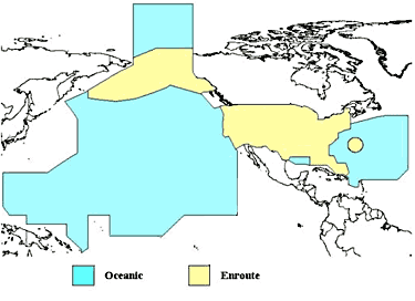
English: A map of the regions where the United States charges overflight fees. Yellow is where higher "enroute" fees are charged. Blue is where "oceanic" fees are charged. The colored regions of this map correspond to the regions where the US has delegated authority by the ICAO to control air traffic, including over international waters. |
| Datum | Datum onbekend |
| Bron | http://www.faa.gov/about/office_org/headquarters_offices/aba/overflight_fees/ |
| Outeur | Federal Aviation Administration |
Lisensiëring
This image or file is a work of a Federal Aviation Administration employee, taken or made as part of that person's official duties. As a work of the U.S. federal government, the image is in the public domain in the United States.
|
 |
Lêergeskiedenis
Klik op die datum/tyd om te sien hoe die lêer destyds gelyk het.
| Datum/Tyd | Duimnael | Dimensies | Gebruiker | Opmerking | |
|---|---|---|---|---|---|
| huidig | 02:52, 9 Augustus 2014 | | 375 × 272 (28 KG) | AHeneen | User created page with UploadWizard |
Lêergebruik
Die volgende bladsy gebruik dié lêer:
Globale lêergebruik
Die volgende ander wiki's gebruik hierdie lêer:
- Gebruik in en.wikipedia.org
- Gebruik in fr.wikipedia.org
- Gebruik in it.wikipedia.org
- Gebruik in ja.wikipedia.org