
Lêer:Capecod oli 2020055.jpeg
Grootte van hierdie voorskou: 600 × 600 piksels. Ander resolusies: 240 × 240 piksels | 480 × 480 piksels | 720 × 720 piksels.
Oorspronklike lêer (720 × 720 piksels, lêergrootte: 145 KG, MIME-tipe: image/jpeg)
Opsomming
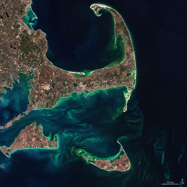
| Beskrywing | The image below—a closeup of Cape Cod, Martha’s Vineyard, Nantucket, and the shoals between them—was acquired by the Operational Land Imager (OLI) on the Landsat 8 satellite on February 24, 2020. |
| Datum | |
| Bron | https://earthobservatory.nasa.gov/images/146412/hints-of-spring-in-the-atlantic |
| Outeur | NASA Earth Observatory images by Joshua Stevens and Norman Kuring, using Landsat data from the U.S. Geological Survey |
Lisensiëring
| This file is in the public domain in the United States because it was solely created by NASA. NASA copyright policy states that "NASA material is not protected by copyright unless noted". (See Template:PD-USGov, NASA copyright policy page or JPL Image Use Policy.) | ||
 |
Warnings:
|
Lêergeskiedenis
Klik op die datum/tyd om te sien hoe die lêer destyds gelyk het.
| Datum/Tyd | Duimnael | Dimensies | Gebruiker | Opmerking | |
|---|---|---|---|---|---|
| huidig | 03:06, 26 Mei 2021 | | 720 × 720 (145 KG) | StellarHalo | {{Information |Description=The image below—a closeup of Cape Cod, Martha’s Vineyard, Nantucket, and the shoals between them—was acquired by the Operational Land Imager (OLI) on the Landsat 8 satellite on February 24, 2020. |Source=https://earthobservatory.nasa.gov/images/146412/hints-of-spring-in-the-atlantic |Date=24 February 2020 |Author=NASA Earth Observatory images by Joshua Stevens and Norman Kuring, using Landsat data from the U.S. Geological Survey |Permission= |other_versions= }} [[Ca... |
Lêergebruik
Die volgende bladsy gebruik dié lêer: