
Lêer:Map of Alcatraz.png

Oorspronklike lêer (1 072 × 825 piksels, lêergrootte: 126 KG, MIME-tipe: image/png)

|
This architecture image could be re-created using vector graphics as an SVG file. This has several advantages; see Commons:Media for cleanup for more information. If an SVG form of this image is available, please upload it and afterwards replace this template with
{{vector version available|new image name}}.
It is recommended to name the SVG file “Map of Alcatraz.svg”—then the template Vector version available (or Vva) does not need the new image name parameter. |
|
|
This city map image could be re-created using vector graphics as an SVG file. This has several advantages; see Commons:Media for cleanup for more information. If an SVG form of this image is available, please upload it and afterwards replace this template with
{{vector version available|new image name}}.
It is recommended to name the SVG file “Map of Alcatraz.svg”—then the template Vector version available (or Vva) does not need the new image name parameter. |
Opsomming
| Beskrywing |
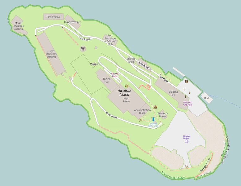
English: Map of Alcatraz Island — former prison and present day park, in San Francisco Bay, California. |
| Datum | |
| Bron | http://www.openstreetmap.org/#map=18/37.82672/-122.42336 |
| Outeur | OpenStreetMap contributors |
| Toestemming (Hergebruik van die lêer) |
http://www.openstreetmap.org/copyright map style: https://github.com/gravitystorm/openstreetmap-carto/blob/master/LICENSE.txt |
Lisensiëring
This screenshot either does not contain copyright-eligible parts or visuals of copyrighted software, or the author has released it under a free license (which should be indicated beneath this notice), and as such follows the licensing guidelines for screenshots of Wikimedia Commons. You may use it freely according to its particular license. Free software license:
| This work contains information from OpenStreetMap, which is made available under the Open Database License (ODbL).
The ODbL does not require any particular license for maps produced from ODbL data. Prior to 1 August 2020, map tiles produced by the OpenStreetMap Foundation were licensed under the CC-BY-SA-2.0 license. Maps produced by other people may be subject to other licences. |
Note: if the screenshot shows any work that is not a direct result of the program code itself, such as a text or graphics that are not part of the program, the license for that work must be indicated separately.
| This file is made available under the Creative Commons CC0 1.0 Universal Public Domain Dedication. | |
| The person who associated a work with this deed has dedicated the work to the public domain by waiving all of their rights to the work worldwide under copyright law, including all related and neighboring rights, to the extent allowed by law. You can copy, modify, distribute and perform the work, even for commercial purposes, all without asking permission.
|
Lêergeskiedenis
Klik op die datum/tyd om te sien hoe die lêer destyds gelyk het.
| Datum/Tyd | Duimnael | Dimensies | Gebruiker | Opmerking | |
|---|---|---|---|---|---|
| huidig | 19:01, 9 Desember 2016 | | 1 072 × 825 (126 KG) | Jeanjung212 | Lossless Compressed/optimized png decreasing file size by 119344 bytes |
| 10:14, 26 Maart 2015 |  | 1 072 × 825 (243 KG) | Mateusz Konieczny | update import from OSM | |
| 11:08, 31 Augustus 2012 |  | 1 188 × 844 (198 KG) | Blofeld Dr. | {{Information |Description ={{en|1=w}} |Source =w |Author =w |Date =w |Permission = |other_versions = }} |
Lêergebruik
Die volgende bladsy gebruik dié lêer:
Globale lêergebruik
Die volgende ander wiki's gebruik hierdie lêer:
- Gebruik in da.wikipedia.org
- Gebruik in en.wikipedia.org
- Gebruik in fr.wikipedia.org
- Gebruik in fy.wikipedia.org
- Gebruik in it.wikipedia.org
- Gebruik in uk.wikipedia.org
- Gebruik in uz.wikipedia.org
- Gebruik in www.wikidata.org
- Gebruik in zh.wikipedia.org