
Lêer:Map of Kiribati CIA WFB.png
Geen hoër resolusie is beskikbaar nie.
Map_of_Kiribati_CIA_WFB.png (325 × 350 piksels, lêergrootte: 9 KG, MIME-tipe: image/png)

|
This map image could be re-created using vector graphics as an SVG file. This has several advantages; see Commons:Media for cleanup for more information. If an SVG form of this image is available, please upload it and afterwards replace this template with
{{vector version available|new image name}}.
It is recommended to name the SVG file “Map of Kiribati CIA WFB.svg”—then the template Vector version available (or Vva) does not need the new image name parameter. |
Opsomming
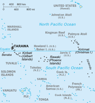
CIA-WF map of Kiribati
Lisensiëring
This image is in the public domain because it contains materials that originally came from the United States Central Intelligence Agency's World Factbook.
|
 |
Lêergeskiedenis
Klik op die datum/tyd om te sien hoe die lêer destyds gelyk het.
| Datum/Tyd | Duimnael | Dimensies | Gebruiker | Opmerking | |
|---|---|---|---|---|---|
| huidig | 15:35, 17 September 2010 | | 325 × 350 (9 KG) | Ras67 | cropped |
| 09:15, 27 Maart 2005 |  | 330 × 354 (10 KG) | Wolfman~commonswiki | {{CIA-map}} |
Lêergebruik
Die volgende 7 bladsye gebruik dié lêer:
Globale lêergebruik
Die volgende ander wiki's gebruik hierdie lêer:
- Gebruik in avk.wikipedia.org
- Gebruik in azb.wikipedia.org
- Gebruik in ban.wikipedia.org
- Gebruik in bjn.wikipedia.org
- Gebruik in br.wikipedia.org
- Gebruik in bs.wikipedia.org
- Gebruik in ceb.wikipedia.org
- Gebruik in cs.wikipedia.org
- Gebruik in da.wikipedia.org
- Gebruik in de.wikivoyage.org
- Gebruik in en.wikipedia.org
- Howland Island
- Jarvis Island
- Line Islands
- Tabuaeran
- List of towns and villages in Kiribati
- Lists of hospitals in Oceania
- Talk:List of sovereign states and dependent territories in Oceania
- List of airports in Kiribati
- Wikipedia:Featured picture candidates/February-2007
- Wikipedia:Featured picture candidates/Kingman Reef
- Outline of Kiribati
- Wikipedia:Graphics Lab/Image workshop/Archive/Nov 2008
- Ministry of Line and Phoenix Islands Development
- Gebruik in en.wikisource.org
- Gebruik in en.wikiversity.org
- Gebruik in eo.wikipedia.org
- Gebruik in es.wikipedia.org
- Gebruik in et.wikipedia.org
- Gebruik in eu.wikipedia.org
- Gebruik in fa.wikipedia.org
- Gebruik in fi.wikipedia.org
- Gebruik in fr.wikipedia.org
Wys meer globale gebruik van die lêer.