
Lêer:West Asia Köppen Map.png
Grootte van hierdie voorskou: 502 × 599 piksels. Ander resolusies: 201 × 240 piksels | 402 × 480 piksels | 990 × 1 182 piksels.
Oorspronklike lêer (990 × 1 182 piksels, lêergrootte: 511 KG, MIME-tipe: image/png)
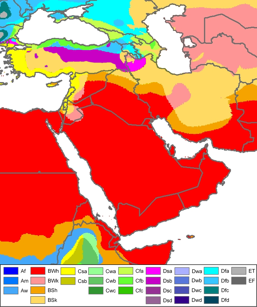
| Peel, M. C. and Finlayson, B. L. and McMahon, T. A. (2007). "Updated world map of the Köppen-Geiger climate classification". Hydrol. Earth Syst. Sci. 11: 1633-1644. ISSN 1027-5606. |
Legend
Opsomming
| Beskrywing | Climate map of (South)west-Asia and adjacent areas (from the "Updated world map of the Köppen-Geiger climate classification"). |
| Datum | |
| Bron | Hydrology and Earth System Sciences: "Updated world map of the Köppen-Geiger climate classification" (Supplement) - Original file was a JPG-file, this file is has been converted to a PNG-file, without extra modifications, by me (Jeroen). |
| Outeur |
Peel, M. C., Finlayson, B. L., and McMahon, T. A. (University of Melbourne) |
| Toestemming (Hergebruik van die lêer) |

|
This meteorology image could be re-created using vector graphics as an SVG file. This has several advantages; see Commons:Media for cleanup for more information. If an SVG form of this image is available, please upload it and afterwards replace this template with
{{vector version available|new image name}}.
It is recommended to name the SVG file “West Asia Köppen Map.svg”—then the template Vector version available (or Vva) does not need the new image name parameter. |
Related maps
User Jeroenvrp made for these continents and areas a cropped and resized version:
- Africa Köppen Map.png
- Asia Köppen Map.png
- Australia-Oceania Köppen Map.png
- Europe Köppen Map.png
- North America Köppen Map.png
- Russia Köppen Map.png
- South America Köppen Map.png
- West Asia Köppen Map.png.
User LordToran made from the same data these maps:
- Klimagürtel-der-erde-eisklima.png
- Klimagürtel-der-erde-gemäßigte-zone.png
- Klimagürtel-der-erde-polargebiete.png
- Klimagürtel-der-erde-subtropen.png
- Klimagürtel-der-erde-tropen.png
- Klimagürtel-der-erde-tundra.png
- Klimagürtel-der-erde-warmgemäßigte-zone.png
- Klimagürtel-der-erde.png
- Klimagürtel-der-erde.svg
- Klimate-humidität.png
- Köppen-geiger-hessd-2007.svg
- Köppen-vereinfacht.svg
- Trockenklimate.png
Lisensiëring
Hierdie lêer is gelisensieer onder die Creative Commons Erkenning-Insgelyks Deel 3.0 Onoorgedraagde lisensie.
- U is vry:
- om te deel – die werk kopieer, versprei en deurgee
- om te hermeng – om die werk aan te pas
- Onder die volgende voorwaardes:
- naamsvermelding – U moet die nodige krediet gee, 'n skakel na die lisensie verskaf en aandui of daar veranderinge aangebring is. U mag dit op enige redelike manier doen, maar nie op enige manier wat daarop dui dat die lisensiegewer u of u gebruik onderskryf nie.
- insgelyks – As u die materiaal hermix, transformeer of voortbou, moet u u bydraes versprei onder die dieselfde of versoenbare lisensie as die oorspronklike.
Lêergeskiedenis
Klik op die datum/tyd om te sien hoe die lêer destyds gelyk het.
| Datum/Tyd | Duimnael | Dimensies | Gebruiker | Opmerking | |
|---|---|---|---|---|---|
| huidig | 12:57, 21 November 2016 | | 990 × 1 182 (511 KG) | Pandakekok9 | Transparent |
| 12:23, 13 Maart 2011 |  | 990 × 1 182 (543 KG) | Maphobbyist | Painted the Caspian Sea as white as it should have been, because the Köppen system is based on the concept that climate types are correlated with the natural vegetation. Thus with Köppen, climate zone boundaries have been selected with vegetation distri | |
| 23:01, 12 Oktober 2007 |  | 990 × 1 182 (507 KG) | Jeroen | Citation: '''Peel, M. C., Finlayson, B. L., and McMahon, T. A.: Updated world map of the Köppen-Geiger climate classification, Hydrol. Earth Syst. Sci., 11, 1633-1644, 2007.''' {{Information |Description= Climate map of North-America (from the "[[:Ima |
Lêergebruik
Die volgende bladsy gebruik dié lêer:
Globale lêergebruik
Die volgende ander wiki's gebruik hierdie lêer:
- Gebruik in ar.wikipedia.org
- Gebruik in de.wikipedia.org
- Gebruik in en.wikipedia.org
- Gebruik in eo.wikipedia.org
- Gebruik in es.wikipedia.org
- Gebruik in es.wikibooks.org
- Gebruik in eu.wikipedia.org
- Gebruik in fy.wikipedia.org
- Gebruik in ha.wikipedia.org
- Gebruik in hy.wikipedia.org
- Gebruik in it.wikipedia.org
- Gebruik in ja.wikipedia.org
- Gebruik in ja.wikibooks.org
- Gebruik in nl.wikipedia.org
- Gebruik in nn.wikipedia.org
- Gebruik in oc.wikipedia.org
- Gebruik in ro.wikipedia.org
- Gebruik in sl.wikipedia.org
- Gebruik in sr.wikipedia.org
- Gebruik in te.wikipedia.org
- Gebruik in th.wikipedia.org
- Gebruik in uk.wikipedia.org
- Gebruik in vi.wikipedia.org