
Lêer:Colombia.A2004117.1535.250m.jpg

Oorspronklike lêer (1 500 × 2 000 piksels, lêergrootte: 898 KG, MIME-tipe: image/jpeg)
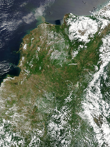
Floods in Colombia, April 2004.
Marshes and wetlands line Colombia’s Magdalena River in its course north from the Andes Mountains to the Caribbean Sea. The wetlands, which form black and blue patches along the river in the false color image, are important for birds arriving from the north for the winter. The area had received heavy rain which triggered floods and landslides. Though the floods aren't visible in these images, the tan plume of sediment flowing into the Caribbean from the Magdalena River in the true-color image may be a result of high, fast-moving waters carrying extra mud into the sea. This true and false color image pair was captured by the Moderate Resolution Imaging Spectroradiometer (MODIS) on the Aqua satellite on April 26, 2004.
http://visibleearth.nasa.gov/view_rec.php?id=6531 archive copy at the Wayback Machine
| This file is in the public domain in the United States because it was solely created by NASA. NASA copyright policy states that "NASA material is not protected by copyright unless noted". (See Template:PD-USGov, NASA copyright policy page or JPL Image Use Policy.) | ||
 |
Warnings:
|
Lêergeskiedenis
Klik op die datum/tyd om te sien hoe die lêer destyds gelyk het.
| Datum/Tyd | Duimnael | Dimensies | Gebruiker | Opmerking | |
|---|---|---|---|---|---|
| huidig | 19:36, 27 Oktober 2005 | | 1 500 × 2 000 (898 KG) | Brian0918 | Floods in Colombia, April 2004. Marshes and wetlands line Colombia’s Magdalena River in its course north from the Andes Mountains to the Caribbean Sea. The wetlands, which form black and blue patches along the river in the false color image, are import |
Lêergebruik
Die volgende bladsy gebruik dié lêer:
Globale lêergebruik
Die volgende ander wiki's gebruik hierdie lêer:
- Gebruik in ar.wikipedia.org
- Gebruik in el.wikipedia.org
- Gebruik in en.wikipedia.org
- Gebruik in fr.wikipedia.org
- Gebruik in ms.wikipedia.org
- Gebruik in ru.wikipedia.org
- Gebruik in sl.wikipedia.org
- Gebruik in uk.wikipedia.org
- Gebruik in vi.wikipedia.org