
Lêer:Polynesian triangle.svg

Size of this PNG preview of this SVG file: 600 × 600 piksels. Ander resolusies: 240 × 240 piksels | 480 × 480 piksels | 768 × 768 piksels | 1 024 × 1 024 piksels | 2 048 × 2 048 piksels.
Oorspronklike lêer (SVG-lêer, normaalweg 600 × 600 piksels, lêergrootte: 281 KG)
Opsomming
| Beskrywing |
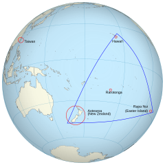
English: An orthographic projection of the pacific ocean, showing land outlines (resolution ~0.5 degrees) and the Polynesian triangle between Hawai'i, Rapa Nui and Aotearoa. Created using perlshaper to convert Natural Earth Data into an SVG file. Some tweaking was then done in Inkscape to fix up boundaries for countries on the edge of the projection. |
| Datum | |
| Bron | Eie werk |
| Outeur | Gringer |
| Ander weergawes | Macedonian version |
| SVG genesis |
Lisensiëring
Ek, die outeursreghouer van hierdie werk, publiseer dit onder die volgende lisensie:
This file is licensed under the Creative Commons Attribution 3.0 Unported license.
- U is vry:
- om te deel – die werk kopieer, versprei en deurgee
- om te hermeng – om die werk aan te pas
- Onder die volgende voorwaardes:
- naamsvermelding – U moet die nodige krediet gee, 'n skakel na die lisensie verskaf en aandui of daar veranderinge aangebring is. U mag dit op enige redelike manier doen, maar nie op enige manier wat daarop dui dat die lisensiegewer u of u gebruik onderskryf nie.
Lêergeskiedenis
Klik op die datum/tyd om te sien hoe die lêer destyds gelyk het.
| Datum/Tyd | Duimnael | Dimensies | Gebruiker | Opmerking | |
|---|---|---|---|---|---|
| huidig | 02:36, 16 Junie 2013 | | 600 × 600 (281 KG) | AnonMoos | adjust margins |
| 11:34, 3 September 2010 |  | 550 × 550 (290 KG) | Gringer | updated with [http://www.naturalearthdata.com Natural Earth Data] | |
| 03:01, 24 November 2009 |  | 542 × 542 (90 KG) | Gringer | {{Information |Description={{en|1=An orthographic projection of the pacific ocean, showing land outlines (resolution ~0.5 degrees) and the Polynesian triangle between Hawai'i, Rapa Nui and Aotearoa. Created using a custom perl script (http://user.interfac |
Lêergebruik
Die volgende bladsy gebruik dié lêer:
Globale lêergebruik
Die volgende ander wiki's gebruik hierdie lêer:
- Gebruik in ca.wikipedia.org
- Gebruik in en.wikipedia.org
- Gebruik in es.wikipedia.org
- Gebruik in fi.wiktionary.org
- Gebruik in fr.wikipedia.org
- Gebruik in hi.wikipedia.org
- Gebruik in ia.wikipedia.org
- Gebruik in la.wikipedia.org
- Gebruik in pl.wikipedia.org
- Gebruik in pt.wiktionary.org
- Gebruik in ru.wikipedia.org
- Gebruik in sr.wikipedia.org
- Gebruik in uk.wikipedia.org
- Gebruik in www.wikidata.org