
Lêer:Satellite image of Spain in January 2003.jpg

Grootte van hierdie voorskou: 714 × 600 piksels. Ander resolusies: 286 × 240 piksels | 571 × 480 piksels | 914 × 768 piksels | 1 219 × 1 024 piksels | 2 437 × 2 048 piksels | 4 175 × 3 508 piksels.
Oorspronklike lêer (4 175 × 3 508 piksels, lêergrootte: 2,42 MG, MIME-tipe: image/jpeg)
| Beskrywing |
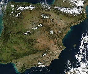
Satellite image of Spain in January 2003. Slightly cropped image, original taken from NASA's Visible Earth http://visibleearth.nasa.gov/view_rec.php?id=4989. NASA's description: The Iberian Peninsula, home to the countries of Spain and Portugal, stretches toward North Africa in this true-color Aqua MODIS image from January 24, 2003. Portugal sits on the Atlantic side of the peninsula, while Spain takes up the rest and shares a border with France to the northeast. At the bottom of the peninsula is a narrow gap between Europe and North Africa. This gap is the Strait of Gibraltar, which also serves as the buffer between the Atlantic Ocean and the Mediterranean Sea. The northern point of Morocco occupies the other side of the Strait, and farther to the east is northern Algeria. |
| Datum | |
| Bron | http://visibleearth.nasa.gov/view_rec.php?id=4989 |
| Outeur | Jacques Descloitres, MODIS Rapid Response Team, NASA/GSFC |
| This file is in the public domain in the United States because it was solely created by NASA. NASA copyright policy states that "NASA material is not protected by copyright unless noted". (See Template:PD-USGov, NASA copyright policy page or JPL Image Use Policy.) | ||
 |
Warnings:
|
Lêergeskiedenis
Klik op die datum/tyd om te sien hoe die lêer destyds gelyk het.
| Datum/Tyd | Duimnael | Dimensies | Gebruiker | Opmerking | |
|---|---|---|---|---|---|
| huidig | 12:54, 20 Desember 2004 | | 4 175 × 3 508 (2,42 MG) | Hautala | {{PD-USGov-NASA}} Satellite image of Spain in January 2003. Slightly cropped image, original taken from NASA's Visible Earth http://visibleearth.nasa.gov/cgi-bin/viewrecord?24848 . Description: The Iberian Peninsula, home to the countries of Spain and Por |
Lêergebruik
Die volgende bladsy gebruik dié lêer:
Globale lêergebruik
Die volgende ander wiki's gebruik hierdie lêer:
- Gebruik in en.wikipedia.org
- Gebruik in es.wikipedia.org
- Gebruik in eu.wikipedia.org
- Gebruik in he.wikipedia.org
- Gebruik in ht.wikipedia.org
- Gebruik in hu.wikipedia.org
- Gebruik in incubator.wikimedia.org
- Gebruik in it.wikibooks.org
- Gebruik in it.wiktionary.org
- Gebruik in nl.wikipedia.org
- Gebruik in pt.wikipedia.org
- Gebruik in uk.wikipedia.org