
Lêer:Yellowrivermap.jpg
Grootte van hierdie voorskou: 800 × 503 piksels. Ander resolusies: 320 × 201 piksels | 640 × 403 piksels | 1 024 × 644 piksels | 1 280 × 805 piksels | 2 497 × 1 571 piksels.
Oorspronklike lêer (2 497 × 1 571 piksels, lêergrootte: 1,19 MG, MIME-tipe: image/jpeg)
Opsomming
| Beskrywing |
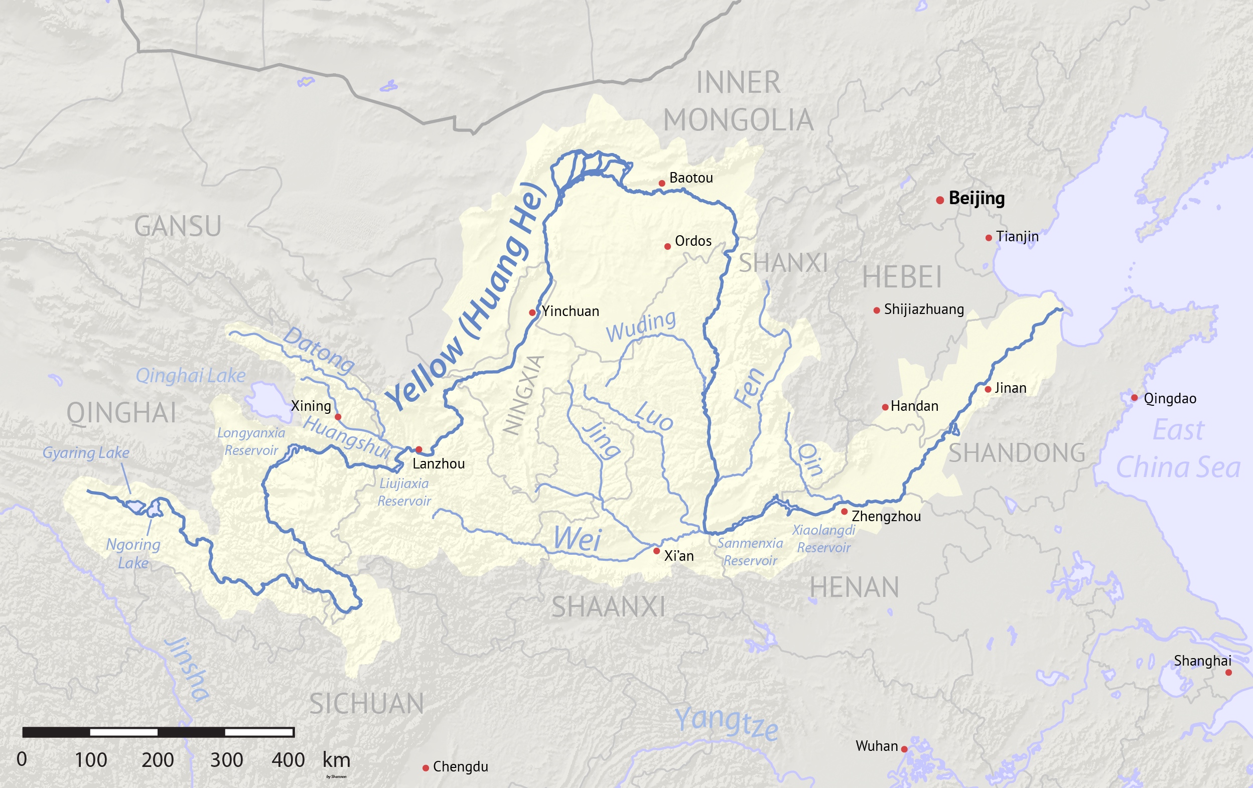
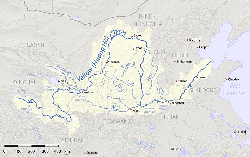
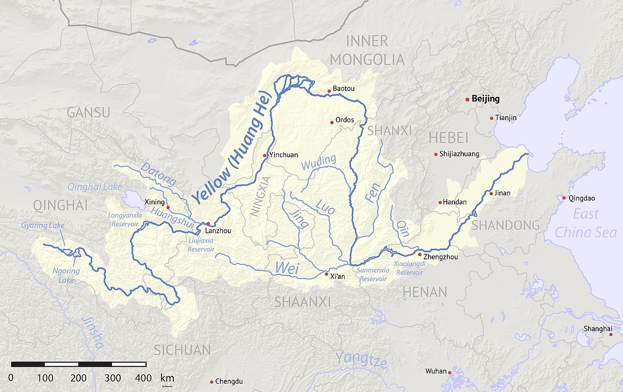
English: Map of the Yellow River, whose watershed covers most of northern China and drains to the Yellow Sea |
| Datum | (2017-08-10 revised) |
| Bron | Created using Natural Earth and NASA SRTM data, both public domain. |
| Outeur | Shannon1 |
| Ander weergawes |
Derivative works of this file: |
Lisensiëring
Ek, die outeursreghouer van hierdie werk, publiseer dit onder die volgende lisensie:

|
Toestemming word verleen tot die kopiëring, verspreiding en/of wysiging van hierdie dokument onder die voorwaardes van die GNU-lisensie vir vrye dokumentasie, weergawe 1.2 of enige latere weergawe uitgegee deur die Stigting vir Vrye Sagteware, sonder Invariante Dele, geen Voorbladtekste en geen Agterbladtekste. 'n Kopie van hierdie lisensie is ingesluit in die afdeling getiteld GNU Free Documentation License. |
This file is licensed under the Creative Commons Attribution-Share Alike 4.0 International, 3.0 Unported, 2.5 Generic, 2.0 Generic and 1.0 Generic license.
- U is vry:
- om te deel – die werk kopieer, versprei en deurgee
- om te hermeng – om die werk aan te pas
- Onder die volgende voorwaardes:
- naamsvermelding – U moet die nodige krediet gee, 'n skakel na die lisensie verskaf en aandui of daar veranderinge aangebring is. U mag dit op enige redelike manier doen, maar nie op enige manier wat daarop dui dat die lisensiegewer u of u gebruik onderskryf nie.
- insgelyks – As u die materiaal hermix, transformeer of voortbou, moet u u bydraes versprei onder die dieselfde of versoenbare lisensie as die oorspronklike.
U kan die lisensie van u keuse kies.
Lêergeskiedenis
Klik op die datum/tyd om te sien hoe die lêer destyds gelyk het.
| Datum/Tyd | Duimnael | Dimensies | Gebruiker | Opmerking | |
|---|---|---|---|---|---|
| huidig | 04:17, 11 Augustus 2017 | | 2 497 × 1 571 (1,19 MG) | Shannon1 | Uploaded clearer version with corrected data. |
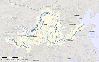
| 02:23, 2 Maart 2010 |  | 1 100 × 544 (401 KG) | Shannon1 | {{Information |Description={{en|1=Map of the Yellow River, whose watershed covers most of northern China and drains to the Bohai Sea}} |Source=Background and river course data from http://www2.demis.nl/mapserver/mapper.asp |Author=[[User:Shannonchan|Shan |
Lêergebruik
Die volgende bladsy gebruik dié lêer:
Globale lêergebruik
Die volgende ander wiki's gebruik hierdie lêer:
- Gebruik in als.wikipedia.org
- Gebruik in an.wikipedia.org
- Gebruik in ary.wikipedia.org
- Gebruik in ast.wikipedia.org
- Gebruik in as.wikipedia.org
- Gebruik in azb.wikipedia.org
- Gebruik in ba.wikipedia.org
- Gebruik in bcl.wikipedia.org
- Gebruik in be-tarask.wikipedia.org
- Gebruik in bg.wikipedia.org
- Gebruik in bh.wikipedia.org
- Gebruik in bn.wikipedia.org
- Gebruik in bo.wikipedia.org
- Gebruik in br.wikipedia.org
- Gebruik in bs.wikipedia.org
- Gebruik in bxr.wikipedia.org
- Gebruik in ca.wikipedia.org
- Gebruik in ceb.wikipedia.org
- Gebruik in cs.wikipedia.org
- Gebruik in de.wikipedia.org
- Gebruik in diq.wikipedia.org
- Gebruik in en.wikipedia.org
- Gebruik in en.wikivoyage.org
- Gebruik in eo.wikipedia.org
- Gebruik in es.wikipedia.org
Wys meer globale gebruik van die lêer.