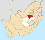
Ngwathe
Voorkoms
Ngwathe | |
|---|---|
| Koördinate: 27°01′S 27°23′O / 27.017°S 27.383°O | |
| Land | |
| Provinsie | Vrystaat |
| Distrik | Fezile Dabi |
| Munisipaliteit | Ngwathe |
| Oppervlak | |
| • Totaal | 2,32 km2 (0,90 vk. myl) |
| Bevolking (2011)[1] | |
| • Totaal | 5 861 |
| • Digtheid | 2 526/km2 (6 540/vk. myl) |
| Rasverdeling (2011) | |
| • Indiërs/Asiërs | 0.1% |
| • Bruin mense | 0.9% |
| • Swart mense | 98.7% |
| • Ander | 0.2% |
| Taal (2011) | |
| • Sotho | 92.3% |
| • Zoeloe | 3.2% |
| • Ander | 4.5% |
| Webwerf | www.ngwathe.co.za |
Ngwathe is 'n township van Edenville in die Noord-Vrystaat van Suid-Afrika.
Verwysings
[wysig | wysig bron]- ↑ 1,0 1,1 1,2 1,3 "Hoofplek Ngwathe". Sensus 2011.


